Thursday 10 March 2016

Wildlife of Spain’s Sierra Nevada


Wildlife of Spain’s Sierra Nevada

Spain’s Sierra Nevada region is unique in that its altitude spans a massive height difference from about 700m above sea level to the Lofty Mulhacen at 3482m. This give it several distinct climatic zones with a huge degree of biodiversity coupled with over 100 endemic species including 63 endemic species of plant. It is situated about 50 miles east of Malaga on the south coast of Spain and just to the south east of the city of Granada and a day out in the Sierra Nevada mountains makes a great option if you are visiting Granada.

Satellite image of The Sierra Nevada showing proximity to the sea. The area in white is snow covered mountains.
The Sierra Nevada was first recognised in 1986 when it was awarded the status of being a UNESCO Biosphere Reserve.  In 1989 it was awarded “Natural Park” status and in 1998 the central area was awarded National Park status becoming Spain’s 11th National Park. 

In terms of size, The Sierra Nevada National Park is Spain’s largest with some 330 square miles. It is surrounded by the Sierra Nevada Natural Park of some 340 square miles, so together they are a massive 670 square miles.

The Sierra Nevada, National Park in green, Natural Park in Blue

The land inside the National Park enjoys a higher level of protection. Additionally, people live within the Natural Park (similar to U.K. National Parks), whereas there are no permanent human settlements in the National Park, only summer farms. The Padul Ponds at the western end of the range are significant wetlands and being in the Natural Park also enjoy a higher level of protection.

To describe the Sierra Nevada we generally divide it into “climatic zones” which have their own characteristics in terms of wildlife though some species (Iberian Ibex, eagles, vultures, etc.) transcend all zones. The only zone that we describe that is not climatic in the same sense is the limestone area of the western edge of the Sierra Nevada which due to its geology has it’s own unique flora.


Mediterranean
Altitude typically below 800m
Terraces of citrus, olives and small holdings.

Wild flowers on the hillside in spring


Purple salsify, Tragopogon porrifolius 
Birds: Crag Martins, Bee Eaters

Animals: Iberien Ibex, common Genet.

Plants: Herbs!

Spring arrives early here, when we can enjoy the terraces of almond, which flowers from February, and citrus where the air can be scented with orange blossom in March and April. Migratory birds are passing through or arriving to nest from March. Wildlife walks at this height are at their best from March through to May.


Fields of wild flowers


High Villages and Farms (e.g. Alpujarra)
Altitude typically 700m to 1600m.
Terraces of Olives, Almonds, Wallnuts, Chestnuts, cherries. Small holdings with Sheep and goats.


Typical Alpujarran landscape, early spring.


Swallowtail, Papilio machaon
Birds: Hoopoes, Bee Eaters, Booted and Golden Eagles.

Animals: Wild Boar, Iberian Ibex.

Plants: Various Orchids, Iris, Rosey Garlic. 

Herbs, Jerusalem sage

Spring starts with the almond blossom, often in February. However it is still a little early to enjoy much else and the weather is still cool. By the end of March the orchids are starting to flower and all through April and May the flowers are stunning and the migratory birds are arriving back.  By June it is getting hot at this level so we now turn our attentions to higher altitudes.

Shepherds walking with their flocks of sheep and goats are a common sight


Pastures of pink fringed orchids, April
White asphodels, March to May


Low Alpine and Summer Farms (Transhumance)
Altitude typically 1600m to 2300m.
Chestnuts and Wallnuts, summer farms.

Resting beside an acequia

The Sierra Nevada Blue  - Polymaths golgus
Birds: Choughs, Ring Ouzel, Eagles and Vultures.

Animals: Wild Boar, Iberian Ibex. Polyommatus golgus butterfly

Plants: St Bruno’s Lilley, Verbascum nevadense, Pyrenean Oak, Holm Oak.

Although it is possible to explore this area in April or May, it is really in June and July that the area is at its best with lovely meadows and flowers, bubbling streams and examples of summer farming (transhumance) still being practised.


Verbascum nevadense an endemic mullien

St Bruno's Lilly - Paradisea liliastrum


Cows returning after a summer in the high pastures


Mid Alpine and Summer Grazing
Altitude typically  2300 to 3000m
Cows grazing “wild” during the summer. Sheep and goats led here daily in summer.

Spring flowers (mid June) in the mid alpine zone, here an abundance of Broom!


Broom - Cytisus galianoi
Birds: Wheatear, Eagles, Vultures

Animals: Iberian Ibex, Beetles, Parnassius apolo butterfly

Plants: Junipers, Brooms, Gentians, Snow Star, Senecio boissieri


To experience the mountainside coloured yellow as the brooms are in flower is a remarkable sight! Herbs in flower with the Broom provides a great setting for butterflys, especially the white Parnassius and the Sierra Nevada Blue. In the wetter areas we are treated to a festival of flowers, gentians and the emblematic Star of the Snows. Mid June and through July are the best months.


The White Apollo butterfly, Parnassius apolo feeding on Thyme


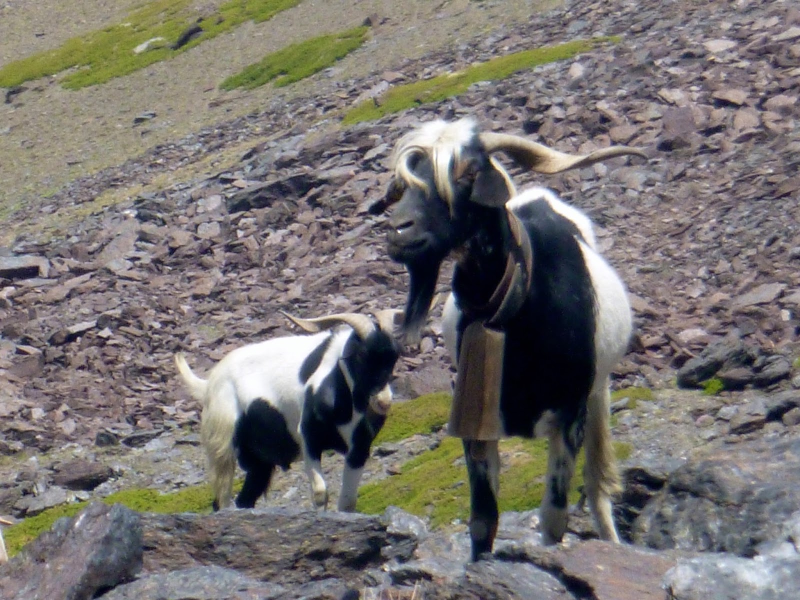
Goats grazing amongst the rocks
Senecio Boissieri, endemic to the Sierra Nevada and Sierra de Gador


High Alpine
Altitude typically above 2900m – “Siliceous High Alpine Grassland”
Fortunately the National Park "Interpretation" Service provides busses to 2700m on the south side of the range and to 3000m on the north side making this area relatively accessible.

Viewpoint near the bus drop off at 3000m on the north side of the Sierra Nevada


Iberian Ibex, Capra pyrenaica, a common sight.
Birds: Alpine Accentor, Alpine Swift, Golden Eagle, Vultures

Animals: Iberian Ibex, Butterflys

Plants: 
Vegetation is scarce, often rare and unique, 
Tyme, 
Artemisia_granatensis,
Viola crassiuscula,
Chaenorrhinum glareosum,
Erigeron frigidus,
Leontodon boryi,
Papaver lapeyrousianum, etc.


The Sierra Nevada Camomile, Artemisia granatensis

This is a magical zone of many endemic and rare plant species, where swifts and swallows soar and dance in the air, where eagles and vultures ride thermals and “Cabra” – Iberial Ibex frequent close to humans hoping to pick up left over sandwiches! When to come very much depends on how much snow there has been. It’s sually o.k. from mid June and most flowers can be seen through until the end of July.


The endemic Sierra Nevada Violet,
Viola crassiuscula
Alpine Accentor - Prunella collaris 


Erigeron frigidus - Cold Fleabane, a rare  endemic plant growing at over 3000m, it is thought only 130 specimens remain.


Borreguiles - High Altitude wetland areas
Altitudes typically between 2600m and 3100m
Famous especially for plants: Veronica nevadensis, Gentiana sierrae, Estrella de las Nieves, Lotus glareosus, Thin Spurred Butterwort – Pinguicula nevadensis.

The "magnificent" Siete Lagunas, largest of all Borreguiles

Near Pico del Caballo
These are protected wetland areas within the National Park found at heights of between 2600m and 3100m. They may be pools, streams or ribbons of dampness, but they are a distinct habitat with numerous endemic species of plant. Because of altitude differences and aspect, these may be snow free from as early as mid April or mid July. Due to the relative low altitude (!) these areas are often in the range of grazing animals (Sheep, goats and cows), so whereas one day there may be a fine display of flowers (gentians), come back a day later and they are gone! May, June and until mid July are good times to plan a visit to these (depending on altitude and aspect).


Lotus glareosus, gravel birdsfoot with gentians and snow stars


The emblematic Star of The Snows, Plantago navalis


The endemic Gentian, Gentiana sierrae


Limestone of the Western Edge
The limestone extends from lower altitudes (Niguelas 950m, Monachil 700m) to the impressive summit of Trevenque 2080m.


The path to Trevenque showing a limestone desert!


Echium albicans (Boragináceas)
Plants: Lavenders, Rosemary, Echium albicans, Convolvulus boissieri, Paeonia coriacea, Junipers 
Brooms, Holm Oak, rock rose


This area is dominated by the impressive Trevenque 2080m, sometimes described as the Matterhorn of the Sierras. A walk to or around Trevenque rarely disappoints between mid April and June. You will almost certainly see Ibex on Trevenque, but it is the plants that are different here to the rest of the Sierra Nevada.


Paeonia coriacea 
Convolvulus Boissieri


Heath Fritillary - Melitaea athalia

Michael Hunt and Jane Livingstone are both International Mountain Leaders based at their Mountain House at 1300m above Lanjaron. IML’s are trained and assessed in environmental issues and environmental interpretation in addition to mountain guiding. Their walking holidays – “Mountain Walking Holidays” offer Wildlife of the Sierra Nevada Walking Holidays or alternatively if you are in the area, and want a day trip to explore some of the wildlife, this can be arranged through Sierra Nevada Guides.


Michael and Jane have been exploring the Sierra Nevada since 2003.


Thursday 19 November 2015

Walking on Gran Canaria

Walking on Gran Canaria

Introduction
Most keen walkers from the U.K. or northern Europe get a bit fed up with the cold damp winter, muddy paths, miserable picnics and daylight fading during the afternoon. Well everyone deserves some winter sunshine and a walking holiday on Gran Canaria is the perfect antedote to the northern European winter blues!

Paths through ancient terraces

Towards Roque Nublo....
Where it is and Climate
Situated approx 150 Km (90 miles) off the west coast of Africa (Morocco / Western Sahara) and 1350 Km (840 miles) south of Europe; Gran Canaria sits well out into the Atlantic and thus has a cooler more temperate climate than mainland Africa. Throughout the year, the average daytime temperature varies from 20 degrees in winter to 26 degrees in summer.  So it is an ideal venue for year round walking. However November to February are the months with the highest rainfall with between 3 and 5 days of rain per month. Having previously visited both Morocco and southern Spain for walking holidays, I shall be returning back to Gran Canaria for my winter “fix” of sunshine in early March where I expect to walk during warm days with plenty of sunshine! Take a look at my holiday.

What is the walking is like?
Sometimes described as ‘a continent in miniature’, Gran Canaria has a variety of landscapes: forests, hillsides covered in pink almond blossom, rocky paths and slopes, almost lunar (volcanic) landscapes, and lush green valleys.  Although there are coastal walks, the best hiking routes are to be found in the centre of the island, where the scenery is varied and often dramatic.

Well signed paths!

Most of Gran Canaria is hilly and mountainous so don’t expect a week of flat easy walking. That said, even in the mountains, there are some shorter and easier walks described by the local walking expert Rambling Roger. Expect a combination of mountain (rocky) paths, forest paths, old mule tracks and driveable dirt track roads. Rambling Roger has published a series of walks throughout the Island, which can be purchased online.  He also is able to send GPX files of the routes if you want to use a GPS device to aid your navigation.


Where to stay
This is a difficult one with no easy answer. Travelling around Gran Canaria even using a car can be a bit slow.  We have even found roads closed for repair with no advanced warning on more than one occasion!

Tejeda

Puerto de Mogan
The greatest concentration of walks are in the centre of the Island.  However in the cooler months the centre of the Island is the coolest place so you might prefer to stay on the coast and drive for an hour (scenic drive) to get to your walk. There is also plenty of cheap (for mass tourism) accommodation down on the coast at Maspolomas. It is the road from Maspolomas that you would take to get inland towards most walks.


If you are more likely to have shorter walks combined with touring and want to stay somewhere with more character on the coast, then a harbour front cottage in Puerto de Mogan is the place to stay.


If you don’t mind it being a little cooler and want to stay in the mountains then take a look at the pretty village of Tejeda, which is where we will be based this coming winter.  From Tejeda both short and long walks can be had straight from your accommodation.


Useful Resources
Rambling Roger is the definitive source of information about walking on the Island.

Maps. To accompany Rambling Roger’s walks, Discovery Walking Guides have produced a 1:50 000 scale map of Gran Canaria which is available from Stanfords.


Roque Nublo


Mountain House Holidays is owned by Jane Livingstone and Michael Hunt, both qualified International Mountain Leaders.  All of the walks they lead during the holiday have been walked beforehand and researched.


Monday 26 October 2015

How to Climb Mt. Olympus

How to Climb Mt. Olympus

This is a record of our first trip to climb Mt. Olympus, Greece’s iconic mountain. We’ll endevour to include as much detail as possible from our 9 months of research prior to the trip and details of the trip itself.  If at the end of this blog you have any unanswered questions, please feel free to contact us.

The Summit of Skala 2866m in the mist!!


We are Mike and Jane, both qualified International Mountain Leaders working for an Organisation called Mountain Walking Holidays.  We were approached in November 2014 and asked if we could lead a trip to climb Mt. Olympus.  We do not routinely take people on routes that we haven’t already done so we set about researching the mountain and studying the map. This blog is about our first "recee" trip

The map to get
The map we got hold of and used for this trip was Mt Olympus,
1:25 000 published by Anavasi.  We bought it online from Stanfords in London. It’s a plastic rip proof map though by the end of the trip some of the printing was peeling off the base.  However due to the poor visibility we encountered it got a lot of use.

Mt Olympus has three peaks: Skala 2866m, Skolio 2905m and Mitikas  2918m. Both Skala and Skolio are accessable to walkers, Mitikas involves some easy but very exposed rock scrambling.

The usual starting point for a trip to climb Mt. Olympus is the small town of Litochoro.  From here depending oun your route it is normal to drive or take a taxi to one of the high starting points. We found a delightful guesthouse, The Palio Litohoro whose owner used to guide on Mt. Olympus. We stayed in Litochoro for the first and last night of the trip. The guesthouse looked after our travel bags whilst we were on the mountain.  The guesthouse also arranged a taxi to take us up to our starting point; around 30 Euro's each way.


Palio Litachoro Guesthouse, highly reccomended

Eating out in Litochorro is easy, there are plenty of restaurants listed on Trip Advisor. We found Meze Meze on the first night, it was so good that we ate there again on our last night. 

The Enipeas Gorge
Most people start their ascent from the road head at Prionia and ascend to “Hut A” for a night before making their ascent of Skala and possibly Mitikas before returning to Hut A for a second night. The descent to Prionia (where you can phone for a taxi) or a further 5 hour walk back to Litochoro via the spectacular Enipeas Gorge.

We had decided against an “in and out” trip favouring a journey through the mountain.  Our plan was to traverse the mountain and if possible take in all 3 summits.

Starting at a high point of Gortsia 1100m we planned to walk to “Hut C” on the Plateau of The Muses at around 2600m. (There are two huts, Hut B and Hut C fairly close together on the Plateau). We chose Hut C because it is smaller and we thought it might have more character.  In hindsight this was a mistake and we’d probably go for Hut B next time!


The walk up to the Plateau of the Muses had only a few short steep sections and was not difficult.  The final pull onto the Plateau had a short section of chain (10m) though this is avoidable by a short detour which is taken by the mule trains that supply the huts. We started walking just after 9am and were at  “Hut C” for 4.15pm.  This included a half hour stop at a really nice hut owned by the local Mountain Rescue Team at Petrostrouga 2120m where we had some tea at around noon.


Mules keep the huts supplied

If you were arriving into the area for late morning or early afternoon, I would consider walking up to the hut a Petrostruga as an alternative to a hotel or guest house in Litochoro.


Arriving at Skourta 2476m

Above Petrostruga the path continues gently up through more ancient forrest. After about an hour the trees end and a short steep pull brings you to a small summit of Skourta 2476m.  From here you follow an impressive ridge line to the Plateau of The Muses 2600m.


The ridge above Skourta with the Muses Plateau visible

Hut C supposedly sleeps 18 people.  The night we stayed it was unpleasantly over crowded though in all fairness the Guardian provided great food.  The facilities include proper squat toilets. Blankets and pillows are provided but you need to take a sheet sleeping bag.  Slippers are also available so you don’t need to carry extra shoes with you.

"Hut C"


As we arrived at Hut C, the mist rolled in and the stunning views that we had enjoyed all day disappeared.

Our plan for the “summit day” was leaving at around 9am to walk the short distance to Mitikas, leave our rucksacks at the bottom of the ascent gully and scramble up to the summit and back.  Then re-united with our kit, follow paths around to Skala and Skolio before descending to Hut A.


We awoke to find ourselves still shrouded in mist and with persistent rain! The Guardian of Hut C told us that it was too dangerous to climb Mitikas in the wet. (polished limestone is notoriously slippery when wet). So we revised the plan to walk around to Skala and make a decision about Skolio. Leaving the hut at 10am we reached Skala, still in the cloud at noon.  We’d had none of what are described as superb views but a great feeling to reach the middle summit of this iconic mountain.

Lunch stop on the descent from Skala


On leaving Hut C, we used our map and compass navigation skills to check our progress across the Plateau and to make sure we picked up the correct path. Although most days through the summer this is an easy mountain to navigate, make sure you have the skills, just in case.  Otherwise hire a guide!!

Back on Skala we were damp and had no views.  Although Skolio is only an easy 1Km walk away, we took the decision to descend down to Hut A 2060m.


Hut A is big!  It’s well equipped, well run and Maria the Guardian is friendly and efficient. But don’t expect a hot shower!  A log fire was burning hot in the dining room and we had a glorious evening with plenty of great food and wine.


Fine Dining in Hut A

Our trip was at the beginning of September.  Chatting to the local guides on the mountain, they confirmed that our choice of route was good but that we should have come in August.  August is apparently the month to climb Mt. Olympus!

The bar at Prionia
It continued to rain all night and there really was a small river running past the Hut in the morning.  However the rain stopped and though we were still in the mist, we set off at 9.15am towards the road head at Prionia 1100m which we reached at noon.

The road head at Prionia is really a car park with public toilets and a nice bar / restaurant. The weather was still not inviting enough for the full 5 hour hike along the Enipeas Gorge so we decided to walk down to the old monestary at Agios Dionisios. The people at the bar were really helpful, after a round of coffee they contacted our taxi and arranged for us to be picked up.  Fantastic.


Agios Dionisios
The old ruined monestary at Agios Dionisios is a pleasant hours walk down the gorge and well worth a visit.  It is now being actively re-built from a ruined state, blown up by the Nazi’s during world war 2.

So with the Taxi collecting us at 1.30pm, we were back at the bar at the bottom of the Enipeas Gorge for lunch.


We shall be running this trip commercially in August 2016.  It is unlikely that the weather will be as bad as that described above.  Come and join us!

Mt Olympus, the view we didn't see. Photo Don Corleonegeorge taken from Hut A's Facebook page